Key Takeaways
Outdoor exploration forms a core element of the local lifestyle in this beautiful country, where rolling peaks and protected forests cover a vast majority of the terrain. Finding the perfect outdoor route requires balancing the geographical layout, the unique seasonal shifts, and the distinct characteristics of each destination.
- Unmatched Urban Proximity: You can easily travel from a bustling downtown subway station straight to a rugged granite mountain summit in under an hour within the capital city.
- Volcanic and Alpine Variety: The landscape shifts dramatically between mainland granite ridges, southern volcanic craters, and sprawling mainland mountain chains that take multiple days to cross.
- Infrastructure Excellence: Well-maintained wooden stairs, durable safety ropes, precise kilometer markers, and clean mountain shelters provide an organized structure to your outdoor adventures.
- Cultural Integration: Historic stone fortress walls, active Buddhist temples, ancient royal shrines, and traditional mountain villages sit directly along these routes, combining physical activity with cultural discovery.
- Strict Preservation Rules: High-altitude national parks utilize a reservation system for certain summits, enforce strict fire bans, require you to carry all your personal trash back out, and strictly control access during specific fire-risk months.
The Ultimate Guide to Hiking in South Korea: Best Trails and Mountains
Imagine stepping off a modern, high-speed subway car, walking past a busy neighborhood market, and immediately entering a silent forest of pine trees and granite boulders. This is the reality of daily life in South Korea, where the natural world is woven directly into the urban environment. Over seventy percent of the Korean peninsula consists of mountainous territory, creating a deep-rooted cultural passion for exploring the great outdoors.
For the local population, ascending a peak is far more than simple exercise. It is a social tradition, a spiritual release, and a weekly ritual that brings together people of all ages. To participate fully in this experience, you must understand the diverse options available across the country.
The Mountain Culture of the Korean Peninsula
To truly appreciate your journey through these forests, you should look at how the local community approaches the wilderness. The relationship between the people and the high ridges goes back centuries, rooted in ancient belief systems that viewed peaks as sacred spaces connecting heaven and earth.
A Vibrant Colorful Subculture
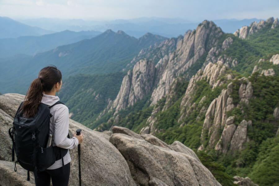
When you arrive at any trailhead on a Saturday morning, you will notice a sea of vibrant colors. Local outdoor enthusiasts dress in high-quality technical layers, matching windbreakers, heavy-duty backpacks, and specialized footwear. Utilizing dual trekking poles is standard practice, regardless of the steepness of the terrain.
The social aspect continues at the summit and along the descent. It is common to see small groups sharing pieces of fresh fruit, dried fish, kimbap (seaweed rice rolls), and cups of traditional rice wine on large flat rocks. After finishing a route, groups usually gather at the base of the mountain to enjoy savory potato pancakes and grilled meats, turning a simple walk into an all-day celebration.
Excellent Safety and Layout
The national park system manages the wilderness with incredible precision. You will find that paths are meticulously shaped to prevent erosion and ensure visitor safety.
- Paved Stone Walkways: The lower sections of major parks often feature smooth stone paths that follow rushing rivers.
- Wooden Staircases: Steep, rocky slopes are frequently converted into long staircases with sturdy handrails, protecting the soil while providing solid footing.
- Safety Support Systems: Exposed rock faces feature thick steel cables and iron rungs permanently bolted into the granite, allowing you to pull yourself up tricky sections.
- Clear Distance Signage: Markers are placed every few hundred meters, showing your current altitude, the distance remaining to the summit, and emergency contact numbers.
Bukhansan National Park: The Granite Crown of the Capital
Located directly inside the northern borders of Seoul, Bukhansan National Park holds a world record for the highest number of visitors per square foot of a national park. Its massive granite peaks rise sharply above the city skyscrapers, providing a spectacular escape for millions of urban residents.
Baegundae Peak Route
The journey to the highest point in the park stands out as a classic capital experience. Starting from the eastern side of the mountain, you walk up along a rushing stream, shaded by a thick canopy of maples and oaks. As the path gains elevation, the dirt under your feet gives way to solid stone slabs.
The final quarter-mile of this ascent requires your full attention. You must hold onto heavy steel wires bolted directly into the exposed granite face. Wind shifts can be strong here, but the rock provides excellent traction for your boots. When you step onto the wide, flat summit of Baegundae, you are treated to a panoramic view of downtown Seoul stretching out to the horizon, with ancient fortress walls winding below your feet.
Sinseondae Peak on Dobongsan
The northern section of the park features the Dobongsan area, famous for its jagged, needle-like rock formations. The route to Sinseondae Peak provides a different visual feel compared to the main summit.
You begin your day passing by quiet Buddhist temples where the sound of wooden gongs echoes through the trees. The trail turns into a steep climb up narrow stone gaps, leading to a dramatic ridge line. Standing on the peak, you look directly across at the vertical rock face of Jaunbong Peak, which remains completely closed to protect rare plant life. The sheer drop-offs around the viewpoint provide an exhilarating sense of space.
The Historic Fortress Wall Route
If you prefer to focus on history while moving through nature, the Bukhansanseong course allows you to follow a stone wall constructed in the year 1711. This defense system was designed to protect the royal family during times of war.
Walking this loop takes you through massive stone gates that have stood for centuries. The path alternates between earth and stone steps, following the natural dips and rises of the mountain ridges. Along the way, you can explore old archaeological sites, hidden storage cellars, and small shrines tucked away in quiet valleys, far removed from the city below.
Seoraksan National Park: Jagged Peaks and Seasonal Colors
Situated on the northeastern coast of the country, Seoraksan is widely considered the most visually dramatic mountain range on the peninsula. Its deep valleys, roaring waterfalls, and twisted pine trees have inspired poets and painters for generations.
The Mighty Ulsanbawi Rock
Ulsanbawi is a massive, six-peaked granite formation that looks like a natural crown sitting on top of the forest. The journey to this iconic landmark begins flat, taking you past the giant bronze Buddha statue at Sinheungsa Temple.
Once you pass the historic hermitage buildings, the real work begins. You must ascend a staircase of over eight hundred steps built directly onto the vertical side of the rock face. As you climb higher, the valley floor drops away rapidly, revealing views of the East Sea in the distance. Reaching the top platforms rewards you with a close-up look at the weathered stone teeth and the constant mountain winds that shape this unique ecosystem.
Dinosaur Ridge Traverse
For experienced wilderness travelers, the Gongryong Ridge, known locally as Dinosaur Ridge, is the ultimate physical test on the mainland. The name comes from the jagged peaks that resemble the spine of a giant prehistoric creature.
This route requires an early start, often before sunrise. You spend hours scrambling over steep rock gaps, descending into deep ravines, and pulling yourself up vertical cliffs using fixed ropes. The vegetation here is stunted by the harsh climate, creating an alpine atmosphere. The reward for this intense effort is a changing view of white stone spires rising out of rolling clouds, far away from any modern roads.
Daecheongbong Summit
The highest point in Seoraksan requires a long, sustained effort through changing forest zones. Starting from the southern Osaek area, the path goes straight up through a dense forest of ancient trees.
This trail focuses on steady elevation gain rather than technical rock scrambles. As you approach the summit, the tall trees disappear, replaced by hearty low-lying shrubs that can survive freezing winter conditions. Standing at the top marker, you can watch the sunrise over the ocean, casting a golden light across the endless rows of mountains stretching toward the interior of the country.
Jirisan National Park: The Sprawling Mainland Wilderness
As the oldest and largest land-based national park in the country, Jirisan spans three different provinces. It is a massive, rounded mountain mass known for its deep biodiversity, hidden valleys, and long ridgelines that can take days to fully explore.
Cheonwangbong Summit from Jungsanri
The absolute roof of the South Korean mainland is Cheonwangbong Peak. The most direct approach begins in the village of Jungsanri, taking you through a valley filled with massive boulders and pristine mountain pools.
The middle section of this route features a steep climb through the “Gate of Heaven,” a narrow rock opening that leads to the high ridges. The final approach moves across open slopes where the weather can change in a matter of minutes. At the top, you look down upon a sea of smaller peaks, a view that has been celebrated in local literature as the ultimate symbol of natural grandeur.
Baemsagol Valley Trail
If you want to experience the deep wilderness of Jirisan without ascending the highest peaks, the Baemsagol Valley provides a spectacular alternative. This path follows a roaring mountain river for several miles.
The trail uses elevated wooden boardwalks that hang over the water, keeping your feet dry while protecting the sensitive riverbanks. You walk past deep emerald pools, small waterfalls, and moss-covered rock formations. The thick tree canopy keeps the air cool even during the hottest summer months, making it a favorite destination for peaceful forest walks.
The Multi-Day Ridge Traverse
The ultimate way to experience Jirisan is by undertaking the multi-day ridge walk, which links the major peaks from east to west. This journey requires careful planning and overnight stays in designated park shelters.
Walking along the spine of the mainland, you witness the landscape change throughout the day. In the early morning, deep fog fills the valleys, creating the illusion of islands floating in a white sea. You pass through high-altitude meadows, historic battlegrounds, and remote springs, experiencing a level of isolation that is rare on this developed peninsula.
Hallasan National Park: Summiting the Volcanic Island Peak
Dominating the center of Jeju Island, Hallasan is a shield volcano and the absolute highest mountain in South Korea. The park is a UNESCO World Heritage site, celebrated for its unique volcanic geology and diverse plant species that vary by altitude.
Seongpanak Summit Trail
The most popular route to the volcanic crater at the top of Hallasan begins on the eastern slopes. The path features a very gentle incline, moving through dense forests of native oak and cedar trees.
The ground under your feet consists mostly of dark, jagged volcanic rock, which requires careful foot placement to avoid twisting an ankle. As you rise above the clouds, you enter an ancient forest of dead fir trees, their white trunks creating a hauntingly beautiful landscape against the dark volcanic soil. The final section uses a long wooden staircase that brings you directly to the edge of the summit crater.
Gwaneumsa Descent Route
For your journey down from the crater, taking the northern Gwaneumsa trail provides an entirely different visual experience. This route is much steeper and more rugged than the eastern approach.
The trail drops into a massive volcanic gorge, crossing high suspension bridges that sway gently above deep rocky drops. You pass by vertical stone walls, hidden lava tubes, and beautiful mossy waterfalls. The intense green of the vegetation in this humid valley contrasts sharply with the stark alpine environment of the summit, showing the incredible ecological diversity of the volcanic island.
Witse Oreum and the Yeongsil Trail
If you do not have the time or reservation for a full summit attempt, the Yeongsil trail offers quick access to the beautiful high plains of the mountain.
The path climbs quickly past unique rock formations known as the “Five Hundred Generals,” which look like stone statues standing guard on the hillside. The trail opens up into a vast, flat alpine meadow covered in wild azaleas during the spring season. Wooden boardwalks guide you smoothly across this fragile landscape to the Witse Oreum shelters, where you can gaze up at the sheer vertical rock wall of the main volcanic cone.
Comparative Analysis of the Major Peaks
To help you decide which mountain best matches your personal travel style and physical readiness, it helps to look at their core metrics side by side. Each destination requires a different amount of time and a different type of physical preparation.
Essential Trail Specifications
The table below breaks down the key numbers for the signature routes on each of the four major mountains discussed above.
| Mountain Name | Peak Name | Total Round-Trip Distance | Average Completion Time | Primary Terrain Material |
| Bukhansan | Baegundae | 5.2 miles | 4 to 5 hours | Smooth granite slabs, steel cables |
| Seoraksan | Ulsanbawi | 4.6 miles | 3 to 4 hours | Forest dirt paths, metal staircases |
| Jirisan | Cheonwangbong | 7.4 miles | 7 to 8 hours | Rocky steps, packed soil, wood steps |
| Hallasan | Baengnokdam | 12.0 miles | 8 to 9 hours | Volcanic rock, long wood boardwalks |
Trail Environment and Visual Highlights
This section compares the general setting and unique features you will encounter while exploring these distinct regions of the country.
| Mountain Range | Regional Setting | Peak Season | Key Visual Feature | Cultural Landmark |
| Bukhansan | Capital City Limits | Autumn and Spring | White granite domes | Ancient Stone Fortress Wall |
| Seoraksan | Northeastern Coast | Peak Autumn Foliage | Jagged rock spires | Giant Bronze Buddha Statue |
| Jirisan | Southern Mainland | Spring and Winter | Endless rolling ridges | Hidden Valley Rivers |
| Hallasan | Southern Volcanic Island | Winter Snow / Spring Flowers | Volcanic Crater Lake | High-Altitude Plain Boardwalks |
Essential Gear and Preparation for Korean Trails
Because the terrain on these mountains shifts quickly from soft dirt to vertical rock faces, your choice of equipment plays a major role in your overall comfort and safety. Local retail shops carry top-tier items, but knowing what to pack before you arrive at the trailhead will save you time and money.
Footwear and Traction
You should leave casual shoes at your hotel when planning a summit hike. The smooth granite of Bukhansan and the sharp volcanic stones of Hallasan require sturdy footwear with specialized rubber outsoles designed for high grip.
- Trekking Boots: Mid-cut boots provide crucial ankle support when moving over uneven stone steps and long staircases.
- Sticky Rubber Soles: Look for footwear that features high-friction rubber, which prevents slipping on wet or polished rock surfaces.
- Moisture Management: Waterproof linings are helpful during the humid summer monsoon months or when crossing small valley streams.
Technical Clothing Layers
The weather at a mountain summit can be twenty degrees cooler than the temperature at the city base, and wind speeds can increase dramatically on open ridges.
- Moisture-Wicking Base: Avoid cotton shirts, which hold sweat and cause chills when you stop to rest. Use synthetic or merino wool fabrics instead.
- Insulating Mid-Layer: A lightweight fleece or packable down jacket provides warmth during early morning starts or extended rests at the summit.
- Outer Wind Shell: A breathable, windproof jacket is essential for protecting your body from the strong gusts found on open granite ridges.
Specialized Accessories
Small tools can make a significant difference over a long day of ascending and descending steep slopes.
- Dual Trekking Poles: Using poles reduces the impact on your knees by up to twenty-five percent during long descents on wooden staircases.
- Personal Trash Bag: National parks do not provide trash cans along the trails. You must carry all food wrappers and empty bottles back out with you.
- Portable Power Bank: Cold temperatures and constant photo-taking can drain your smartphone battery quickly. Keep a backup power source handy for navigation apps.
Seasonal Highlights: When to Plan Your Journey
Each season transforms the Korean wilderness into a completely different visual landscape. Planning your visit around these natural cycles allows you to experience the country at its most beautiful.
The Autumn Foliage Rush
From late September through mid-November, a wave of brilliant color moves from the northern mountains down to the southern valleys. Maple trees turn deep crimson, while oaks and ginkgos shift to bright gold. Seoraksan is the prime destination for autumn color, drawing large crowds who come to see the red leaves framing the white granite cliffs.
The Spring Blossom Awakening
As the winter ice melts in April, the hillsides fill with delicate pink and purple colors. Wild azaleas and rhododendrons bloom across the high alpine meadows, particularly on the southern slopes of Jirisan and the plains of Hallasan. The weather during this period is generally dry and comfortable, making it a wonderful time for long day walks.
The Winter Snowscape Transformation
Winter brings a quiet beauty to the high peaks. Heavy snowfalls transform the volcanic dome of Hallasan and the ridges of Deogyusan into a wonderland of white. The moisture in the air freezes onto the branches of alpine trees, creating delicate ice structures known locally as rime ice. You must wear metal microspikes on your boots during this season to safely navigate the icy steps.
Trail Rules and Respecting the Local Environment
The incredible cleanliness and safety of the local park system rely on mutual respect between visitors and nature. Adhering to the established guidelines ensures that these spaces remain beautiful for future generations.
The No-Trace Policy
You will notice a complete absence of waste bins once you pass the main park entrance gates. This intentional policy requires every hiker to take full responsibility for their personal waste. You should bring a dedicated bag inside your backpack to store fruit peels, wrappers, and containers until you return to an urban area.
Staying on Marked Routes
To prevent soil erosion and protect rare alpine plant species, you must strictly remain within the boundaries marked by wooden fences and ropes. Shortcuts are forbidden, especially on fragile slopes like the volcanic soil of Jeju Island or the steep ridges of Seoraksan.
Respecting Sacred Spaces
Many routes pass directly through the grounds of active Buddhist temples. When walking near these historic wooden structures, you should lower your voice, avoid taking photographs of the interior shrines where monks are praying, and step carefully over the raised wooden doorsills of the temple buildings.
Frequently Asked Questions
Do I need to pay an entrance fee to visit the national parks in South Korea?
National park entry is entirely free of charge across the country. You can enter the trailheads and explore the mountain routes without purchasing a ticket. However, if you choose to enter specific historic temple grounds located inside the park boundaries, a small separate cultural preservation fee might be requested at the temple gate. Additionally, if you drive a personal vehicle to the trailhead, you should be prepared to pay a standard daily parking fee at the main visitor lot.
How do I make reservations for the restricted summit routes like Hallasan?
To protect the unique volcanic ecosystem of Hallasan, the provincial government limits the number of daily visitors allowed to reach the summit crater. You must log onto the official park reservation website well in advance of your trip to secure a free climbing pass. Once registered, you will receive a QR code on your mobile phone, which park rangers will scan at the main trail entrances. mainland parks like Jirisan also require advanced online bookings if you plan to sleep overnight in their mountain shelters.
Is public transportation available to reach these remote mountain trailheads?
The transportation infrastructure makes accessing the wilderness exceptionally convenient. For city mountains like Bukhansan, you can simply take a standard metro line directly to a station near the base of the peaks. For more distant destinations like Seoraksan or Jirisan, frequent express buses run from the central terminals in Seoul straight to the mountain gateway towns. Local city buses or affordable taxis can then take you from the local terminal directly to the park visitor centers.
What should I do if I get injured or lost while out on a mountain trail?
The emergency response system in the national parks is highly efficient. In the event of a medical emergency or severe disorientation, you can dial the national emergency number, 119, from any mobile phone. Along every major route, you will spot square metal location markers posted on trees or rocks every few hundred meters. These signs display unique coordinate numbers that you can read to the emergency operator, allowing rescue teams to pinpoint your exact position quickly.
Are there options to purchase food and drinking water along the mountain routes?
You will find small convenience markets, outdoor gear shops, and traditional restaurants concentrated around the main entrance plazas at the base of every major mountain. These spots are excellent for purchasing bottled water, fresh kimbap, and snacks before you start your ascent. Once you pass the main gate and head up into the forest, there are no commercial shops or vending machines. You must carry an adequate supply of hydration and food to sustain your energy levels until you return to the base.

